onX Offroad: Trail Maps & GPS
- 3.6
- Rating
- 1.00M
- Installs
- Free
- Price

 Analysis by App-foxy
I approached onX Offroad: Trail Maps & GPS as someone planning a real off-road day rather than casually browsing a map. That distinction matters. This is a Maps & Navigation app from onXmaps built around trails, public-land boundaries, and private-property information, so its value appears before the vehicle leaves the driveway. It helps turn a vague idea such as “find somewhere legal and interesting to drive” into a route-planning task with more context.
The app is free to install and suitable for Everyone, which makes trying it fairly easy. Its current version is 26.4.0, and it runs on Android 8.0 or later. I would still treat the free download as an introduction rather than assuming every useful capability is included without limits, because in-app purchases range from $9.99 to $99.99 per item. The important question is not simply whether it opens a map, but whether its trail and land information fits the way you travel.
Getting from installation to a useful first trip
Before setting out, I’d use the first session to test one nearby trail area and see whether its map details answer practical questions, not just look promising on screen. I’d also decide what information I want ready before the drive, so the next section can focus on building a simple, useful plan without turning preparation into a project.
You May Also Like

 Blood Strike: 2.5 Anniversary
Blood Strike’s Loadouts Turn Every Drop Into a Tactical Gamble
A close look at Blood Strike’s custom loadouts: how fast access to signature weapons reshapes its battle royale rhythm, rewards preparation, and narrows the gap between fights.

 Pandora - Music & Podcasts
Pandora’s Music Is Easy to Start, but Harder to Recover
Pandora’s strength is its low-effort path from a seed to a station. Its weak spot is how much confidence it asks you to place in connection, setup, and quiet recovery.

 8 Ball Pool
 Is Built on Rivalries, Rematches, and Routine
A close look at the rivalries, rematches, shared routines, and unanswered safety questions that turn a quick pool match into a persistent mobile community.

 Samsung Music
’s Quiet Strength Is Playing What You Already Own
Its reach comes less from spectacle than from dependable access to a personal library. That simplicity is both the app’s strongest retention engine and its ceiling.

 AccuWeather: Weather Radar
AccuWeather Review: A Quick, Clear Forecast for Everyday Decisions
For everyday plans, the best forecast is the one you can understand quickly. AccuWeather makes rain timing, radar, and local conditions easy to act on, with a few trade-offs.

 Hill Climb Racing
Why Hill Climb Racing Still Turns Crashes Into One More Run
A tiny car, a bumpy hill and one more upgrade: Hill Climb Racing keeps resurfacing because its simple chaos makes every near-miss feel personal.
More From Our News Desk



What the first launch is really for
My first recommendation is to resist the temptation to zoom around randomly. Start by choosing an area you genuinely expect to visit. The app becomes easier to judge when the map represents a weekend plan, a hunting-access question, a forest-road outing, or a familiar off-road destination. A broad map can look impressive, but a nearby test area reveals whether the coverage and land details are useful for your kind of trip.
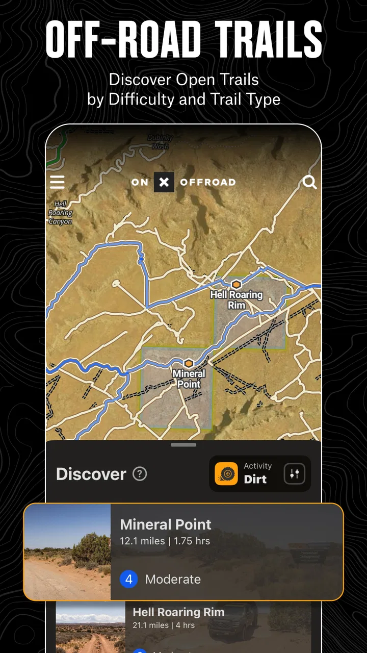
The interface is more purposeful than a normal road-navigation app. A typical phone map is excellent at getting you to a town, a business, or a marked address. It is much less helpful when the destination is an unnumbered trail, a junction on public land, or an access point beside property boundaries. onX Offroad is aimed at that gap. I found the most useful mindset was to use it as a planning and orientation tool, not as a replacement for common sense, local signs, or responsible land-use decisions.
That distinction also explains who may find it unnecessary. If your driving stays on paved roads and you only need turn-by-turn directions to established destinations, a conventional navigation app will probably feel faster and simpler. This app earns its place when the route itself is part of the adventure and the legal or geographic context matters.
Setting up without overcomplicating the map
After installation, I would begin with the smallest practical area rather than trying to plan an entire region. Search for a destination or move the map to a known trail network, then pause and inspect what is shown around it. Look for the relationship between the trail, nearby public land, and private property. The useful result is not merely seeing a line on a screen; it is understanding what surrounds that line before you commit to driving it.
A good first setup also means deciding what information you need before leaving home. If you are comparing several possible routes, save your choices in a simple order: starting point, main trail, possible exit, and a backup area. That workflow is more reliable than opening the app at the trailhead and trying to interpret everything under time pressure. It also makes the app useful for a group, because you can explain the plan using recognizable map references instead of saying, “We will just follow the road until it looks right.”
I would spend a few minutes learning the difference between a trail line and the surrounding land information. New users can easily assume that a visible route automatically means unrestricted access. It does not make sense to treat a mapped line as permission. Property boundaries, public-land context, local closures, gates, seasonal restrictions, and signs on the ground still deserve attention. The app can improve awareness, but it cannot remove the responsibility to verify access.
The developer, onXmaps, has clearly focused this product on outdoor navigation rather than general commuting. That focus is helpful because the map encourages questions ordinary navigation apps often leave unanswered: What lies beside this trail? Is the route connected to a larger network? Where might a private parcel affect the plan? Those questions are exactly why I would install it.
Your first meaningful success
The first successful action should be modest: choose one realistic trail area and build a plan that includes an alternative. For example, imagine leaving early on a Saturday to explore a forest-road network. Before departing, I would locate the main approach, identify the intended trail, inspect nearby land ownership information, and mark a second route or exit. The success is having a sensible plan before the vehicle moves, not simply finding the most remote-looking line.
That backup-route habit is one of the app’s strongest practical uses. Off-road plans can change because of weather, a blocked section, a vehicle limitation, or an access concern. A map that helps you see surrounding options is more valuable than one that only points toward a single destination. I prefer planning a conservative primary route and keeping a shorter retreat available rather than treating the most ambitious route as the only successful outcome.
Another useful habit is to inspect the map at several zoom levels. At a wider view, I can understand how the trail network connects to roads and communities. At a closer view, I can examine junctions and property relationships. Switching between those perspectives prevents a common mistake: choosing a route because it looks connected when the connection is actually unclear at the point where it matters.
For a first trip, I would also share the plan verbally with anyone riding along. Explain the intended start, the point where you may turn around, and the backup. This is not a glamorous feature, but it makes the map easier to use in the real world. If reception becomes unreliable or attention is divided by driving, everyone benefits from already knowing the basic route.
Where beginners commonly get confused
The biggest confusion is likely to be the difference between information and authorization. A property boundary shown on a map is valuable because it alerts you to a potential issue, but it is not a substitute for permission. Likewise, a trail displayed in the app should not be interpreted as a guarantee that conditions, gates, or access rules are unchanged. I would use the map to ask better questions, then follow posted signs and current local guidance.
Another point of friction is the expectation that this works exactly like a car-navigation app. Someone accustomed to entering an address and receiving a perfectly guided sequence of turns may find the off-road experience more hands-on. The app is better suited to exploring, comparing, and understanding routes than to removing every decision from the driver. That is a strength for experienced users, but first-time off-road travelers should not mistake map confidence for driving confidence.
It is also easy to overload the screen with too much information. When I am planning, I want enough detail to understand access and route choices, but not so much that the intended path disappears among nearby lines and labels. Zooming in for decisions and zooming out for orientation is more effective than leaving the map at one level throughout the entire planning session.
Users may also wonder whether the free version is enough. My practical answer is to install it, test the area you care about, and see whether the available map context supports your actual decision. The purchase range indicates that additional value may depend on the level of access or tools you need. I would not pay simply because the app is designed for off-roading; I would pay only after confirming that it improves a repeated planning problem for me.
How it compares with familiar alternatives
Compared with Google Maps or Apple Maps, this app is less convenient for ordinary errands but more relevant to trail-focused planning. Those mainstream options excel at addresses, businesses, traffic, and paved-road travel. They are not designed around the question of how a trail relates to public and private land. If your trip begins on a highway and ends at a marked campground, a standard map may be all you need. If the interesting part begins after the pavement ends, onX Offroad has the more appropriate perspective.
It also differs from a paper trail guide. A printed guide can be easy to read, does not depend on a battery, and may offer useful local commentary. However, it is less flexible when you want to compare surrounding routes or inspect the relationship between a trail and property boundaries. I would happily carry both on a serious trip: the app for interactive planning and a backup reference for resilience.
Compared with a basic GPS track viewer, the advantage here is the land and trail context. A track can tell you where a line goes, but it may not answer what kind of land surrounds it or how nearby routes connect. The trade-off is that a dedicated off-road map can feel more specialized and may require more preparation from the user. That is a fair exchange if access awareness is central to your outing.
The app’s average rating is 3.4 from around 5.8 thousand ratings, with roughly 2.7 thousand written reviews, and it has passed one million installs. I read those figures as a sign of a useful but not universally effortless tool. The audience is broad enough to include many expectations: casual explorers, serious off-road drivers, land users, and people who simply want a better map for remote areas. A mixed experience is understandable when the quality of a navigation app depends heavily on location, trip style, and user preparation.
Three practical habits that make it more useful
First, plan the return before the departure. Many people focus on reaching the trail and forget that the exit may be more important after a long day, changing weather, or reduced daylight. I would inspect the route back and identify at least one point where turning around remains easy. This makes the app a decision aid rather than a one-way adventure generator.
Second, use land information to shape behavior, not just route selection. If a trail approaches private property, I would treat that as a prompt to slow down, check signs, and avoid assuming that a nearby line is an invitation. This is a subtle but important benefit: the map can encourage better judgment even when it does not provide the final answer about access.
Third, test your planning routine close to home. Pick a short, low-consequence outing and practice locating a trail, checking its surroundings, and choosing an alternate. That teaches you how quickly you can interpret the map before you are tired, cold, or dealing with a group that wants to keep moving. A small test trip can reveal more than an hour of abstract browsing.
A fourth habit is to separate exploration from navigation. At home, I would freely compare areas and examine connections. In the vehicle, I would keep the task simple: confirm the next decision, stop when necessary, and avoid manipulating the phone while driving. The app is most helpful when it supports deliberate choices rather than becoming another distraction on a technical route.
Who should use it and who should skip it
I would recommend onX Offroad to people who regularly explore unpaved routes, plan trips around trail networks, or need a clearer view of public and private land relationships. It is especially useful for a first-time planner who feels uneasy about accidentally crossing into an area they should avoid. The map’s value is not just finding somewhere to drive; it is helping you prepare with more awareness.
I would be more cautious about recommending it to someone who wants effortless spoken directions, a simple commute tool, or a map that eliminates the need to verify conditions. It is also not the right sole resource for a high-consequence trip where a dead battery, poor connectivity, or outdated local conditions could create serious problems. In those situations, I would combine it with offline preparation, a backup navigation method, and current local information.
The age rating of Everyone makes the app approachable for households and mixed-age groups, but the activity itself still demands adult judgment. A young passenger can enjoy helping identify landmarks or follow the planned route, while an experienced adult should remain responsible for access decisions and safe driving. The rating describes the app’s audience, not the difficulty of the terrain it may help you reach.
My next-step recommendation
If you are curious, install the free app and begin with a destination you can realistically visit soon. Do not judge it by how attractive the map looks at maximum zoom. Judge it by whether you can answer practical questions: Where does my route begin? What surrounds it? What is my fallback? What will I do if the intended trail is unsuitable when I arrive?
After that test, decide whether the paid options are justified by your routine. Someone taking one occasional scenic drive may be satisfied with a basic planning workflow and a conventional map alongside it. Someone repeatedly exploring trails may find the specialized context worth paying for, particularly if it saves time during route research and reduces uncertainty around land boundaries.
My overall view is positive, with an important condition: the app works best when it supports preparation rather than replacing judgment. It gives off-road travelers a more relevant starting point than ordinary road maps, and its public-land and private-property context can change how responsibly you plan. At the same time, it asks you to interpret information, respect signs, and keep a backup plan. For that reason, I would recommend it to a thoughtful first-time user who wants to make one well-prepared trip, not to someone looking for a magic button that guarantees every trail will be open, simple, or legal to drive.
Used that way, onX Offroad becomes more than a trail browser. It becomes a practical pre-trip workspace: a place to narrow choices, understand the surrounding land, prepare an alternate, and arrive with a clearer idea of what success looks like. That is enough to make it a worthwhile addition to an off-road toolkit, provided you pair the screen with current local awareness and sensible decisions on the ground.
FAQs for onX Offroad: Trail Maps & GPS
01What is onX Offroad and how can it enhance my off-roading experience?
onX Offroad is a trail mapping and GPS app designed for off-road enthusiasts. It offers detailed trail maps, offline navigation, and real-time updates to ensure a safe and enjoyable off-roading adventure. With features like 3D maps and tracking capabilities, it enhances your experience by providing comprehensive trail information and helping you explore new routes confidently.
02Can I use onX Offroad without an internet connection?
Yes, onX Offroad allows you to download trail maps and use them offline. This feature is particularly useful in remote areas where internet connectivity is limited. By downloading maps beforehand, you can access vital trail information and navigate without interruptions, ensuring you stay on track even when offline.
03What types of vehicles are supported by onX Offroad?
onX Offroad caters to a wide range of off-road vehicles, including ATVs, dirt bikes, 4x4s, and side-by-sides. The app provides specific trail information for different vehicle types, allowing users to choose routes that best suit their vehicle's capabilities. This ensures a safer and more enjoyable off-roading experience tailored to your specific needs.
04How does onX Offroad ensure the safety of its users?
onX Offroad prioritizes user safety by offering features such as real-time weather updates, trail difficulty ratings, and user reviews. These tools help users make informed decisions about trail conditions and readiness. Additionally, the app's GPS tracking ensures you can easily share your location with friends or family, adding an extra layer of safety during your adventures.
05Is there a subscription fee for onX Offroad, and what does it include?
onX Offroad offers a subscription service that provides access to premium features, including unlimited offline map downloads, 3D maps, and detailed trail information. While a free version is available with limited features, the subscription enhances your off-roading experience by offering comprehensive tools and data to explore trails more effectively. Pricing details are available on the app's official website or download page.
Pros
- Comprehensive trail database.
- Offline maps available.
- GPS tracking is accurate.
- User-friendly interface.
- Regular updates with new trails.
Cons
- Subscription required for full access.
- Heavy battery usage on long trips.
- Limited free features.
- Occasional map loading delays.
- Some trails lack detailed info.

onX Offroad: Trail Maps & GPS
Gallery